Race Day: SATURDAY, JANUARY 17, 2026
Course Description
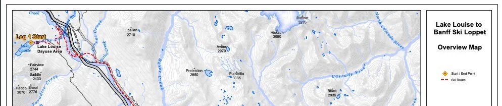
The 42km Lake Louise to Banff Loppet is a longstanding cross-country ski event in the Bow Valley. It begins on Lake Louise and proceeds to valley bottom via the Tramline trail with an out and back section on Moraine Lake Road. The course proceeds along the valley bottom, crossing over the Bow River, under the TransCanada, over the iconic Morant’s Curve and through long sections of lodgepole pine forest. The Loppet is a stunning journey for all souls (soles?) that is cherished by skiers new and seasoned.
The Loppet starts at 10h00 on Saturday, January 17th, 2026
Start line is on the frozen Lake Louise
Finish line is at Castle Junction (NOT Sawback Day Use area)
The solo event is 42km or can be completed in teams of 2-4 people
This is a semi-wilderness event. Expect twigs, willows, small stones.
Please note the turnaround point in Leg 1 on Moraine Lake Road
The course is comprised of trails maintained by Parks Canada, Baker Creek by Basecamp, Castle Mountain Chalets and Loppet volunteer-groomed ski trails
There is one time cutoff at 1:45pm at Baker Creek (3.75hrs after the start)
This event is a classic technique style only
Leg 1 of 4 [17km]
Summary: Start on Lake Louise (10am). Finish for relay leg 1 is at Lake Louise railway crossing (in Lake Louise Campground)
New: descend the Tramline Trail, hard right hand turn, out and back on Moraine Lake Road (3km each way, 6km total)
Total climbing 156m, Total descent: 359m
2 road crossings over Lake Louise Drive, remove skis to cross
Finish at Lake Louise railway crossing
The Loppet starts on the iconic Lake Louise in front of Fairmont Chateau Lake Louise. The trail proceeds behind the Lake Louise public parking lot then takes a hard right hand turn to link onto the Tramline trail groomed by Parks Canada. After descending along the Tramline, the course takes a sharp right hand turn onto Moraine Lake Road. The course proceeds along the right hand side of Moraine Lake Road for a gradual climb of 3km until the Paradise Creek Parking Lot turnaround point. Skiers will turnaround here (marked by orange flags and a stationed volunteer, no feed station here) to return the same 3km; this time it’s downhill! Then, the course takes a hard right hand turn to link back onto the Tramline trail. Skiers continue downhill to the first road crossing. Skiers must take their skis off and cross when safe to do so. There will be no snow shovelled onto the road, volunteers are there to help you cross but vehicles maintain the right of way.
Once over the road crossing, skiers descend further on a new section of Parks Canada trail to the lower Lake Louise Drive road crossing. Again, skiers must take their skis off and cross when safe to do so. There won’t be any snow shovelled onto the road here. Skiers then parallel the Bow River to a footbridge, cross into the Lake Louise Campground and meet the first exchange/checkpoint at the Level Rail Crossing (see Google Map pin). If you are skiing Leg 1, you exchange your timing chip to Leg 2 here. Be sure your starter for Leg 2 knows where to meet you! They need to drive through the Lake Louise Campground to park.
Leg 2 of 4 [11km]
Summary: Lake Louise railway crossing (in Lake Louise Campground) to Baker Creek Trailhead
Total climbing: 45m Total descent: 65m
Run/walk/ski in ditch over Morant’s Curve
Cross over the Parkway at Baker Creek Chalets
1:30pm cutoff at Baker Creek Chalets (3.5hrs after start)
Finish at Baker Creek Trailhead
Leg 2 starts at the Lake Louise level railway crossing (review Google Map as a team!). You can drive close to the start through the Lake Louise Campground, please park on Campground roadway to avoid congestion near railway crossing. There is a striped black and yellow gate; go left here to access start. The exchange station is on the Lake Louise campground side of the railway.
If you’re only skiing Leg 1, do not cross the tracks. Exchange your timing chip to Leg 2 here. There will be volunteers at the railway crossing helping with parking, food, drink etc. After crossing the railway tracks, the course travels under the TransCanada Highway and up onto the iconic Morant’s Curve. Depending on the snow year and grooming ability, skiers may need to run/walk this section on Morant’s Curve until the trail begins again.
After cresting Morant’s Curve and descending the other side, the trail parallels a long stretch beside the railway, through the Baker Creek Chalets, crosses the Bow Valley Parkway and finishes at Baker Creek Trailhead (not the Chalets!). Despite the stunning scenery, you must make it to the Baker Creek exchange by 1:30pm in order to proceed!
Leg 3 of 4 [10 km]
Baker Creek Day Use Area to Castle Lookout Trailhead
Total climbing: 72m Total descent: 113m
2 road crossings (Protection Mountain campground and Castle Lookout)
Leg 3 is arguably the best combo of approachable terrain and beautiful scenery. This leg starts at Baker Creek Lot and proceeds towards Protection Mountain Campground. For those waiting for their teammates, the Baker Creek Day Use is a good place to station yourselves. There is parking lot parking and public washrooms. There is also a volunteer feed station at this exchange. There is a road crossing at the Protection Mountain Campground, typically serviced by none other than longtime volunteer, Back Swamp George. Once crossing the parkway and saying ‘hello’ to George, skiers continue east towards Castle Lookout Parking lot. This leg boasts great views of Pilot Mountain and you’re on the original Parkway route! There is a road crossing with snow across the Parkway right before a short and steep pitch up to Castle Lookout. The exchange station is the Castle Lookout trailhead.
Leg 4 of 4 [4km]
Castle Lookout to Castle Junction (finish)
Total climb: 7m Total descent: 33m
The final Leg 4 starts at Castle Lookout Trailhead. The course continues east under a power line until a final descent among the narrow Lodgepole Pine; mind your speed on this section! No road crossings on this leg. The final skier/soloist finishes at Castle Junction! Woohoo you’re done!
Please use the public parking lots (do not park along the Parkway), enjoy a post-race refreshment and treat yourself to a snack at the Castle Mountain Chalets shop.
bear in mind.
The Loppet is skied on a semi wilderness trail. We advise you to carry bear spray with you and know how to use it.
The course follows trails maintained by Parks Canada, Castle Mountain Chalets, Baker Creek by Basecamp and our dedicated team of volunteer groomers. Thank you!
